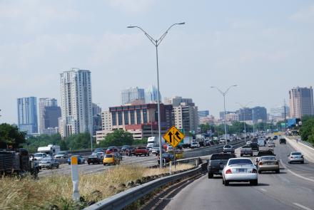
Though I have lived in Austin since I was four years old, I was virtually unaware of I-35's effects on the city when I was younger. Growing up in West Austin, I was ignorant about socioeconomic and racial inequities in the city. I first discovered the demographic division caused by I-35 when I was eleven. I had purchased Small Steps by Louis Sachar, and the context he gave for the novel struck me. I was surprised and a little ashamed that I, an Austinite, was unaware of the social dynamic in my own backyard.
"Interstate 35 goes from the Mexican border all the way up to Lake Superior, and some of the heaviest traffic is along the two-hundred-fifty mile stretch between San Antonio and Dallas. The steady flow of cars and trucks divides the city of Austin in half, not just geographically, but also economically, and to some extent, racially."
-Small Steps by Louis Sachar
Small Steps is Austinite Louis Sachar's first young adult novel dealing with the themes of racial and economic oppression on a local, observable level. Small Steps is the contrasting companion of Sachar's book Holes, which depicts a wrongfully sentenced white boy from the "wrong side of the tracks," who eventually makes it out of his desperate situation. Theodore, the black main character of Small Steps, finds that he cannot escape the assumptions people make about him based on his East Austin address, forcing the readers of Holes and Small Steps to acknowledge the racial discrepancy. Sachar admits in an interview that Theodore and Stanley endure equal suffering in Holes, but Theodore creates a more complex character because he does not return home to wealth and a fresh start. Small Steps creates the opportunity to explore life on the other side of Austin's racial barrier, I-35.
Interstate 35, according to the Texas Freeway history website, was originally a two lane highway that was not intended to be incorporated into the interstate system. In the early 1950s, I-35 was known as US-81, and there was no difference between West side and East side. As you can see from the photo, both sides of US-81 featured businesses and houses of similar appearance.
Soon after the interstate underwent construction in 1959, the city became divided by East and West, and East and West began to imply certain racial heritage and socio-economic status. Today, I-35 physically separates the less affluent East Austin from the booming, bustling scene of West Austin and downtown. The infrastructure, though "building" the city, was destroying it and cutting off its circulation, causing its growth to stunt in East Austin.
I-35 detaching the East side from the lights of downtown.
Source: www.nytimes.com
The inequity between the East and West sides and the division caused by I-35 is an issue in the forefront of most socially-aware Austinites' minds. The Austin blog, Questions of Quantity, has multiple posts discussing quantifiable evidence of the divide and debate over a solution. When the blogger searched Google Maps for SAT tutors and orthodontists in Austin, she found that all those businesses are located west of I-35, while businesses for trailer home rental are located on the east side. The people of Austin are not only divided by I-35, but they are limited by it. In Austin's case, the roads of the city physically separate its natives from certain places and opportunities. Even the picture above illustrates interesting contrast between the east and west: the West side is the focus of the photo, and it's full of light and life, while the East side is dark and barely in the picture.
Though the pictures can accurately portray the discrepancy between the east and the west, there is a plethora of quantitative proof as well. According to the US census data the Questions of Quantity blogger found, the average median income for an East Austin household in 2000 was $15,678, while the average was $48,950 for Austin overall, which is almost three and a half times more. 34.1% of households in East Austin are single parent households, which is shocking compared to Austin's overall percentage of single parent households: 8%. Yet another divider, according to the 2000 census, is the gap in education. In East Austin, 54.4% of adults never finished high school, while in Austin overall, only 15.2% of adults lack a high school diploma.
My personal experience with this astounding education gap began when I began to volunteer with Breakthrough Austin in my sophomore year. Breakthrough helps kids who will be the first in their families to attend college achiever their academic goals. Through the mentoring program St. Stephen's does with Breakthrough, I became more acutely aware of the discrepancies between my Austin experience and the experience of most of the students.
One of the projects I did with my students was a Google Maps project in which we chose locations historically important to East Austin and those locations on the east side that are important to the Breakthrough students. Over the course of three months, we researched, refined our map, and prepared a walking tour. On the day of the tour, I got to see the places my students had researched for so long and watch them present what they had learned with the confidence and certainty of someone much older. That Saturday, I was truly inspired by their hard work and dedication to their academics. I also enjoyed being in a part of Austin I rarely spent any time in. This project not only expanded my world, but it gave me hope that one day, the people of Austin will overcome the physical, racial and economic divisions the city has placed on them.
"Pennybacker Bridge" is the official name of the structure we Austinites refer to as the "360 Bridge". The structure was named after Percy Pennybacker, a former designer for the Texas Department of Transportation (TXDOT). It was designed by Clearwater Constructers out of Colorado and opened to traffic on December 3, 1982. Although it spans 1,150 feet, the bridge does not touch the comfortable waters of Lake Austin. It was designed as such in order to allow boat traffic to move freely under it. The bridge is upheld by 72 steel cables, each of which is connected to the arched support beams grounded in either side. It was the second bridge of it's kind built in the world.
The Pennybacker Bridge serves as more than just as a medium for crossing this dammed section of the Colorado River. It additionally serves as a connector for two very different pieces of the city as well as a hub for recreation of all types. This bridge is truly host to a 'boatload' of activity. It sits perpendicular to the Austin Country Club Golf Course as well as the lake which runs under it. Each every warm day of the year, boats cruise just 100 feet below it. People visit the areas near this bridge in order to escape from the high entropy of the city they work in. The bridge is witness to a host of emotions from the dwellers of the city pass over it each and every day. By morning, parents are driving children to school and adults are hastily headed to work, most distracted by thoughts of the day ahead. By afternoon, people have lost the stress they carried by morning, their minds flow as freely as the boats which skim atop the water. People use the urban space in a variety of ways, utilizing each and every square inch of this urban oasis of grass and water. The bridge however, is a constant, always standing as a symbol of the versatility of the city of Austin as shown by those who pass over and under it each and every day. It's not in every city that you can go to work by morning and be on the lake in the afternoon.
Below is a neat 3-D Model of the Pennybacker Bridge:
Here is a link to a 360 degree panorama taken from a position adjacent to the bridge.
Its 5:30. I’m trapped on I-35, known at the “worlds’ largest parking lot”. I have been stuck in traffic for over 30 minutes and I have to be downtown in less than 10 minutes with 3 miles left until I can exit…FML!
Traffic is part of our lives for those that live in Austin. Heavy traffic stimulates anger and frustration from many impatient drivers with a busy schedule. Traffic congestion is very heavy during the time of rush hour, from 6- 9am and 4-7pm on weekdays, as people are driving to and from work. Even though traffic in Austin is not as bad as other major populated cities like New York City, sitting in traffic is still very annoying.
In modern society, time is money. People are constantly running around: getting to work, getting home, going to school, picking someone up, having a meeting somewhere, going to the movies, etc. Therefore, speeding has significantly increased because people are always in a rush to get to where they need to be.
Interstate 35 is the most annoying place to be when there is traffic. There is no room to breathe. Joe Taylor a traffic reporter for News 8 Austin describes that I-35 is "designed for a small town, and [Austin] has grown into a very large city." Since 2000, Austin's population growth has increased 15.4 percent in 2008.
As the city of Austin continues to grow, the roadways become smaller and tighter during rush hour as more people are driving on the road. According to Katherine Gregor, a journalist for The Chronicles, "the metric used to document congestion is a road's volume-to-capacity ratio, which compares the existing volume of traffic (flow rate) to a street's real capacity." A capacity of .8 or lower means that there is less traffic. However, downtown I-35 is said to have a capacity of over 1.0! I-35 is not the only roadway in Austin with high traffic congestion: Loop 360, Mopac, and Lamar.
Austin's traffic continues to get worse because of the lack of an alternative form of transportation. Capital Metro is one form of an alternative form of transportation that helps to ease traffic in the city; however, this form of transportation is not very popular to the public. In addition, businesses and shops in Austin are often very far apart and it is only convenient to drive, rather then riding a bike or walk.
So what is The Austin Department of Transportation doing in response to driver's frustration to the increase traffic?
The Austin Department of Transportation is constantly readjusting the route of city buses to make it more convenient to the public. The city has also built a Capital MetroRail that runs from downtown Austin to the norther part of Austin. According to Robert Spillar, director of The Austin Department of Transportation, they are trying to build "new sidewalk and bicycle improvements and advocating that people simply drive less, both regionally and in town."
How does traffic affect Austinites?
Some of the obvious reasons are that traffic causes people to be late to their activities and makes people anger. However, traffic also plays a role in car accident. Many people become reckless drivers when they are angry and frustrated in traffic: changing to the faster lane or using the shoulder to cut through traffic. Traffic accidents are heard almost everyday on the radio (KLBJ) and Joe Taylor also updates his Facebook about the incidents. In addition, businesses are also affected by the traffic. High traffic in an area can cause businesses to lose valuable customers because people tend to avoid the cluster of cars.